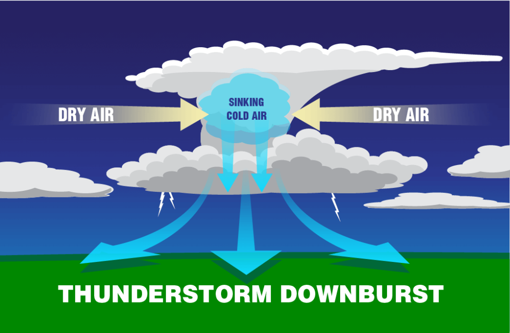
It seems we have heard the word “derecho” multiple times over the last few 5 years. This term is often spoken with multiple pronunciations. The proper one would be “deh-Rey-chos”. The meaning of the word derecho is “straight ahead” in Spanish. First off, what is a derecho? Derochos are fast moving bands of thunderstorms with destructive winds. The winds can be as strong as those found in hurricanes or even Tornadoes! These are straight line winds, and not rotational winds like a tornado. The winds of a dercho travel at least 58 mph and have been recorded as fast as 130 miles per hour. What causes a derecho? It all has to do with something called a downburst. When the wet air in a thunderstorm meets the drier air surrounding it, the water in the air evaporates. When water evaporates, it cools the air around it. Since the cool air is denser, it rapidly sinks to the ground and creates strong winds called downbursts (picture below). Derochos happen when the right conditions for downbursts occur over a wide area. Crazy enough, a derecho’s path of damage is at least 240 miles long! Satellites are doing a better job of picking up the potential for derechos from space to give communities a lead time warning for the threat. One of the most impactful derechos happened on August 10, 2020 in Iowa. This storm boasted wind speeds of 140 mph and caused widespread devastation throughout the city. Every corner of the 75 square mile city was impacted in some way, making it one of the most costly thunderstorms in U.S history. Derechos can happen at any time, but typically we see the threat increases early summer into fall. Spring time is peak of severe storm season, with supercells being the primary factor. As we heat up and we do not see those strong intense cold fronts, more linear style thunderstorms begin to be more dominant. These lines of storms and segments can combine into a bowing line and grow upscale into a derecho. The science community continue to research using Artificial Intelligence as well as satellite data to help develop a model that will identify the potential of these destructive storms. Subby
Some information obtained from NOAA Scijinks as well as the Cedar Rapids .org city website.