


I have been highlighting some local disasters/emergencies in our area over the last couple weeks. I have not done this to create fear upon our community, but to drive home the fact that we are not immune from such disasters. We have looked at a couple of tornado events and today we are going to take a look at a threat that is present every year; flooding. We have had many flooding disasters throughout the years including 1977, 1982, 1998, 2011 and so on. We are going to look at the flood of 1993 today and how it impacted our area.
Known as the “Great Flood of 1993,” this flood is considered to be among the most expensive ever in the United States, with total damages of over $15 billion and an overall death toll of 50, of which at least 13 took place in Missouri. This flood evolved from a series of heavy rain events along the Missouri and Mississippi Rivers, culminating with a crest of 49.58 feet and a flow of 1.08 million cubic feet per second on August 1 on the Mississippi River at St. Louis. On this day about 23 miles downstream of the St. Louis gage, the town of Valmeyer, IL, was flooded. The citizens of town decided not to rebuild the town at the same location, opting to rebuild on top of a nearby river bluff. Earlier along the Missouri River, the town of Rhineland, MO, upstream of Hermann, MO, was also destroyed and later rebuilt on higher ground.
The areas of record flooding extended well upstream of both the Missouri and Mississippi Rivers within Missouri, including western Illinois, western Wisconsin, southern Minnesota, southeastern South Dakota, eastern Nebraska, and much of Kansas, Missouri and Iowa. Months of heavy rainfall followed a winter of near to above average snowfall to produce significant spring flooding over much of Missouri. For the first 7 months of 1993, United States Department of Agriculture/Agriculture Stabilization and Conservation Service county offices reported more than 50 inches of rainfall in Osage, Sullivan, and Worth counties, more than twice their normal totals. In June and July, the rainfall intensified as mainly nocturnal thunderstorms affected much of the lower Missouri and middle Mississippi River basins.
Throughout the Midwest, at least 75 towns were completely inundated, an estimated 54,000 people were evacuated, and about 50,000 homes were damaged or destroyed by the flooding. And personal impacts extended well beyond flooded structures. In Iowa, for example, tens of thousands of people were unable to work due to a lack of public water supplies needed for sanitation, fire fighting, and routine operation of businesses.
Transportation was severely affected throughout Missouri. At one point in July, all road bridges between St. Louis and Burlington, IA, were closed due to flooding. On Friday, July 16, only 5 of 28 bridges connecting Missouri with Illinois were open. At one point, all bridges crossing the Missouri River between St. Louis and Kansas City were closed, along with sections of Interstates 29, 35, and 70 across Missouri, all at considerable cost to the trucking industry. Along the Mississippi River, barge traffic was halted for over a month, costing the barge industry between $3-4 million each day. The rail industry suffered losses of over $300 million, with more than $100 million in losses in Missouri alone. Damages to locks and dams and levee systems were staggering. Over a thousand levee systems, including 40 federal levees, were damaged or destroyed.
The agriculture industry also experienced huge losses. More than 600 billion tons of topsoil was removed by the flood and deposited downstream. Over a million acres was flooded, and much of it was farmland. All of this was a complete loss at harvest time, resulting in a total agricultural loss of $1 billion.
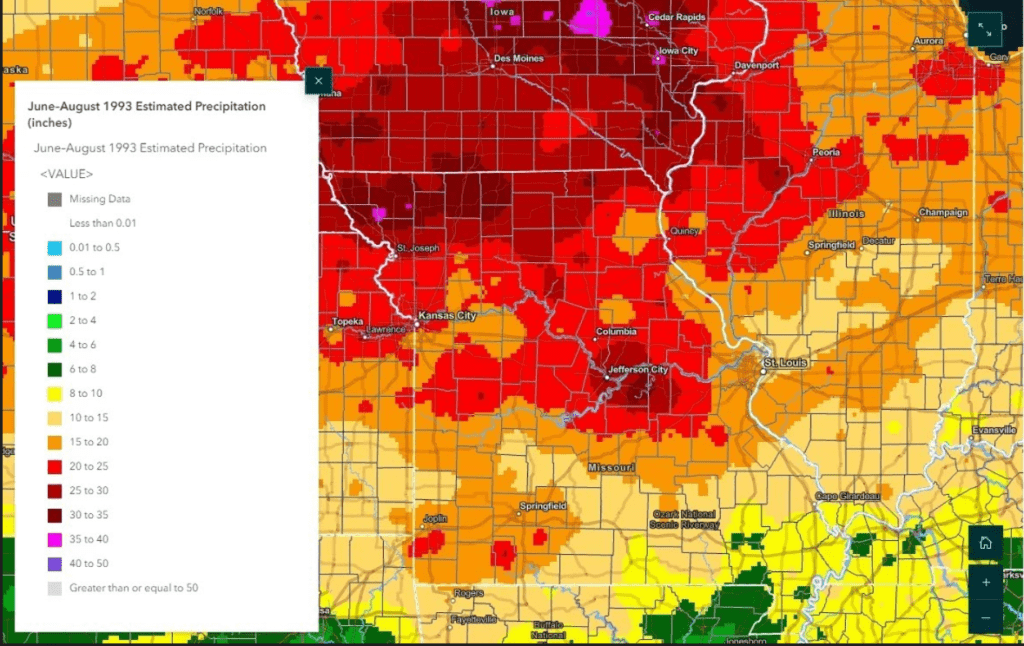
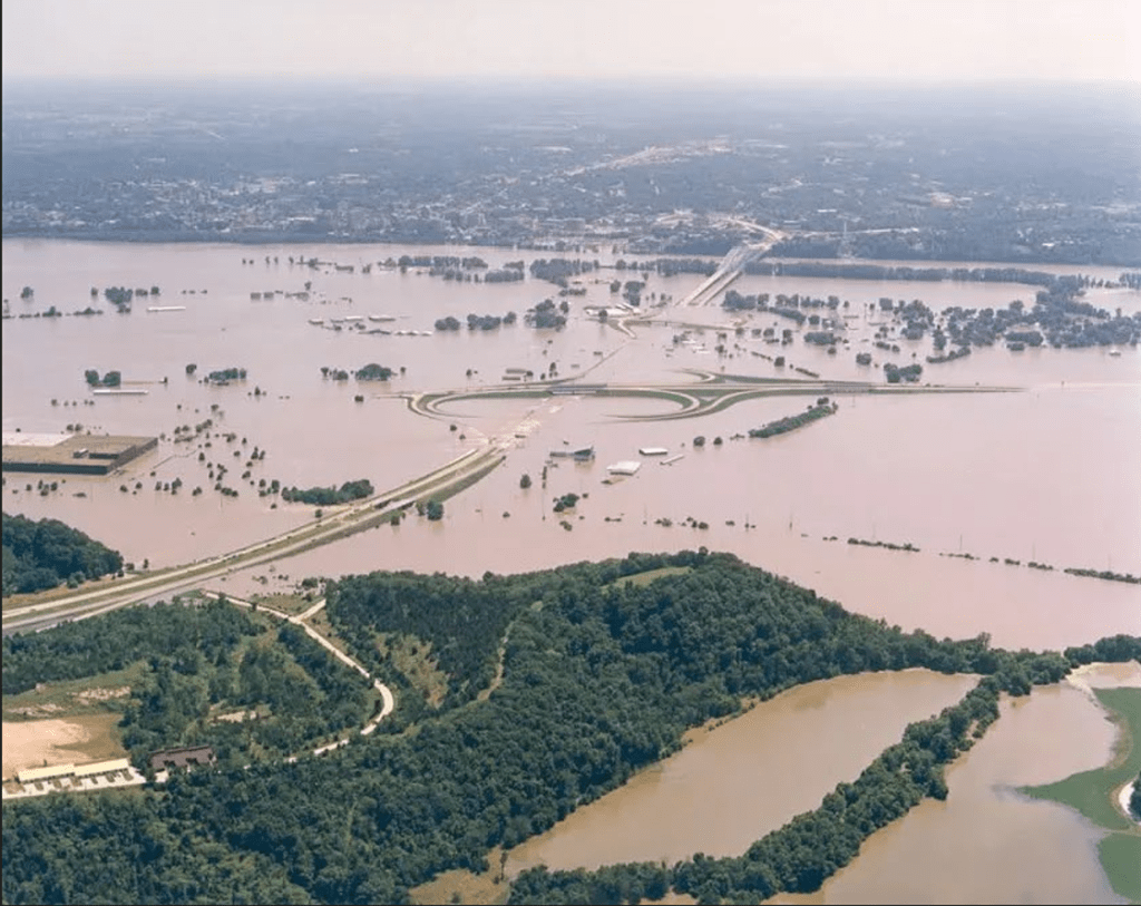
More locally, on July 3, a flood emergency was declared to exist within the Corps of Engineers’ Kansas City District, which encompasses much of northern Kansas and western Missouri, and portions of Iowa, Nebraska and Colorado. Henry, Cass, Johnson, Pettis, Benton and Bates counties had an estimated 23” of rainfall from June to August of 1993. The Grand River and Big Creek rivers had record breaking stages and crop fields were flooded throughout the area (picture 1 from NWS). The state of Missouri was split into two along the Missouri River, making it nearly impassable. At the peak of the flooding on June 30th, 1993, only a single bridge remained open along its entire span of the Missouri River, from Kansas City to St. Louis (picture 2 taken just north of Jefferson City by MoDot). Obviously this is disastrous for our community and to our farmers in West Central Missouri. We constantly battle high flood stages along the Grand River, Big Creek and other rivers and streams year after year. We hope and pray to not have another “100 year flood” in our area, but we must remain vigilant and prepared none-the-less. We learned many great lessons because of this disaster that will make us stronger and more knowledgeable going forward. This is what it takes for our community to be more resilient and able to withstand any threat that is laid upon us. Subby
(Information obtained from the National Weather Service Archive)