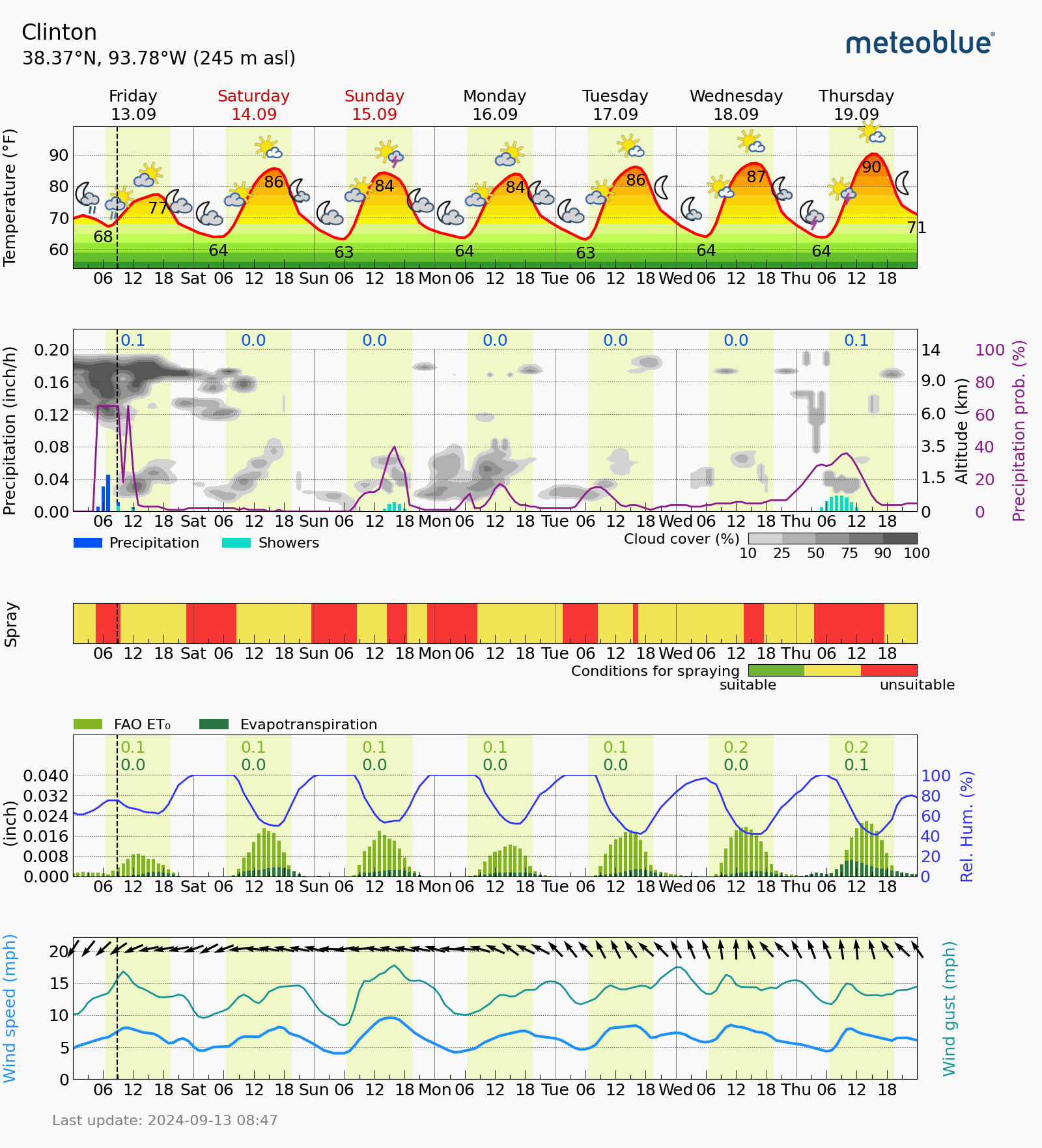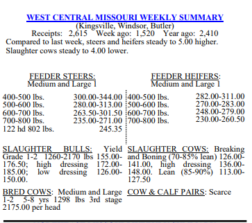


The remnants of what was Hurricane Francine is still being stubborn and will sit out to the east of WCMO and spin some cloud cover and sprinkles throughout the weekend. We are not expecting any measurable precipitation. The long range forecast is picking up some momentum for some moisture finally. We will have a system close by next week that could provide the focus for more significant rainfall as well as a severe threat by the end of the week. No doubt things are very dry as the drought index is slowly going up over our area. Here is a word from the Ag Meteorologist from the USDA and I will leave you with our current Ag Meteogram and this weeks WCMO cattle report. Subby
In the West, cool air continues to replace previously hot conditions. Any lingering heat is generally confined to the southern Rockies and parts of the Desert Southwest. A freeze warning is in effect early today in parts of south-central Oregon, while high-elevation snow lingers across the northern Rockies. On the Plains, showery weather in parts of Montana and the Dakotas is slowing final harvest efforts for barley and spring wheat. Elsewhere on the Plains, warm, dry weather is ideal for summer crop maturation and harvesting, although soil moisture is broadly lacking for the germination and proper establishment of newly planted winter wheat. In the Corn Belt, rainfall associated with Post-Tropical Cyclone Francine has spread as far north as southern and eastern Missouri and southern sections of Illinois and Indiana. Across the remainder of the Midwest, warm, dry weather favors corn and soybean maturation. Dryness is also promoting fieldwork, including initial winter wheat planting efforts. In the South, the post-tropical remnant circulation of former Hurricane Francine is nearly stationary and centered over northern Arkansas. Showers associated with Francine have become more scattered but remain locally heavy from the northern Mississippi Delta to the Atlantic Coast States, extending as far north as the Tennessee Valley and the Carolinas. In the wake of Francine’s strike, more than 100,000 customers in Louisiana remain without electricity. Outlook: The remnants of Francine are forecast to dissipate over the mid-South later today or Saturday, although additional rainfall could still total 3 to 6 inches or more in northern and central Alabama and environs. Meanwhile, a low-pressure system expected to form near the southern Atlantic Coast may acquire subtropical or tropical characteristics before moving inland across the Carolinas early next week. Regardless of development, locally heavy rain may fall in portions of the southern and middle Atlantic States during the first half of next week. Meanwhile, a Western storm system arriving late in the weekend may entrain moisture associated with Eastern Pacific Tropical Storm Ileana, leading to an increase in shower activity. By early next week, showers may spread as far east as the Plains. In contrast, mostly dry weather will prevail during the next 5 days from the Great Lakes region to New England. The NWS 6- to 10-day outlook for September 18 – 22 calls for the
likelihood of above-normal temperatures in most areas from the Plains eastward, while cooler-than-normal conditions will cover the West. Meanwhile, near- or above-normal precipitation across most of the country should contrast with drier-than normal weather in the western Gulf Coast region, parts of the Southwest, and an area stretching from the eastern Corn Belt to New England.