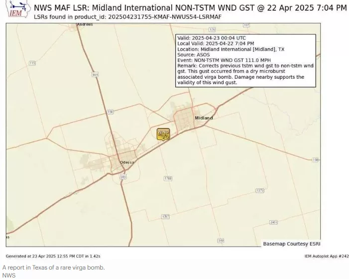
Earlier this week the Midland, Texas region experienced 111 mph winds and associated damage. According to the National Weather Service, these high winds were not associated with an EF tornado. NWS meteorologists say they were caused by a relatively rare weather phenomenon called a virga bomb. What’s that? In a statement issued by the NWS, forecasters wrote, “This gust occurred from a dry microburst associated virga bomb. Damage nearby supports the validity of this wind gust.” A microburst is a very localized region (2.5 miles in diameter or less) of sinking air typically associated with a thunderstorm, according to a NWS website. A related phenomenon called a macroburst is similar but has a diameter greater than 2.5 miles. Meteorologists have identified several factors that, in isolation or some combination, can cause microbursts. They include:
- The presence of hail and/or precipitation.
- Evaporation of rainfall and associated cooling beneath the cloud base.
- Dry air entering the cloud (entrainment).
- Sublimation (ice to water vapor) if the cloud base is above the freezing altitude.
- Dry conditions beneath the cloud
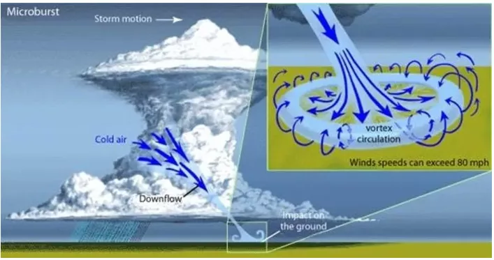
- The NWS website goes on to say, “Microbursts can be subdivided into three primary types — wet, dry, and hybrid. Cooling beneath the thunderstorm cloud base and sublimation are the primary forcing mechanisms with dry microbursts.” A dry microburst was relevant to the virga bomb reported in Texas. Virga is defined by the Glossary of the American Meteorological Society as, “Wisps or streaks of water or ice particles falling out of a cloud but vaporizing before reaching the earth’s surface as precipitation…. Under some conditions, virga is associated with dry microbursts, which are formed as a product of the vaporization.” In other words, the extreme burst of wind is not associated with much, if any, precipitation at the surface due to dry conditions beneath the cloud. Wet microbursts are more common and are often associated with both entrainment of mid-level dry air and precipitation loading. Hybrid scenarios also exist. What’s interesting about these phenomena is the sudden “burst” of wind at the surface. The NWS website notes that once evaporational cooling and sinking air weakens the updraft, it becomes increasingly difficult for the hail or rain core to be suspended. The website continues, “The core plummets to the ground. As it hits the ground it spreads out in all directions. The location in which the microburst first hits the ground experiences the highest winds and greatest damage.” While the virga bomb associated with recent Texas damage was the result of 111 mph winds, there are reports of winds reaching 150 mph in some microburst cases. Microburst signatures are fairly distinctive on Doppler radar, and they usually have a clearly-defined damage pattern on the ground. It is common for people to attribute damage to tornadoes that ends up being associated with microbursts. They certainly pose a hazard to society that extends beyond your next flight. (***reference Forbes magazine and NOAA***)