Agricultural Weather Highlights – Friday – July 19, 2024
In the West, monsoon-related showers are mostly limited to the Great Basin and the Four Corners States. Meanwhile,
hot, dry weather in the Pacific Coast States and the Northwest is maintaining heavy irrigation demands but promoting
fieldwork and a rapid pace of crop development. Smoke from Western wildfires is reducing air quality in several areas,
including much of southeastern Oregon.
On the Plains, widely scattered showers and thunderstorms are developing. However, hot weather on the northern High
Plains contrasts with near- or below-normal temperatures across the remainder of the nation’s mid-section. The High
Plains’ heat is promoting the development of Northern crops, such as barley and spring wheat.
In the Corn Belt, a high-pressure system centered over northern Illinois early today is maintaining cool, dry Midwestern
conditions. Warmth is returning, however, west of the Missouri River, accompanied by scattered showers in Nebraska
and the Dakotas. Currently, only 5% of the U.S. production area for both corn and soybeans is experiencing drought,
according to the July 16 U.S. Drought Monitor.
In the South, a stalled front is generating showery weather from the coastal Carolinas to eastern Texas. In areas of the
Southeast that have been affected by hotter- and drier-than-normal weather in recent weeks, rain is helping to replenish
topsoil moisture and ease stress on pastures and summer crops. Still, the pattern change may have arrived too late to
substantially benefit some early-maturing Southern crops, including corn.
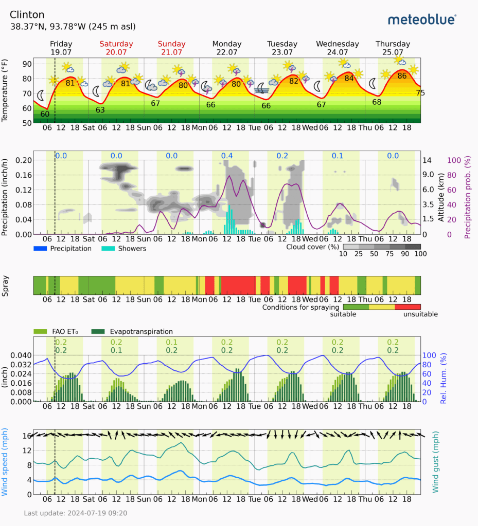
Here in West Central Missouri, I am seeing an active stretch of weather beginning on Sunday and lasting through most of the week. Current hydrology outlooks show most of WCMO in a 1/2″ to 1″ band through next Thursday. With current soil moisture content, this could lead to some standing water and wash off. The first few days of August is also shaping up to have above average precipitation. Here is a set of graphs I like to look at that I hope you find informational. It consist of a future-cast of temperature, precipitation, spraying conditions, windspeeds and evapotranspiration. Have a great weekend!
Information was sourced through Subby’s Weather Talk Online, USDA’s World Agricultural Outlook Board, Office of the Chief Economist and Meteoblue.