We are expecting just below average to average temperatures going into next week with just a couple chances of seeing any precipitation in West Central Missouri. By next weekend, we will begin to warm up ahead of an approaching cold front that will affect WCMO the last couple of days in August as well as the first week into September. I encourage you to give a listen to my latest podcast, where I take a look at the LRC and what September holds for us here in our area. You can find my podcast here: https://www.communityfirstpodcasts.com/podcast/subbys-weather-talk/
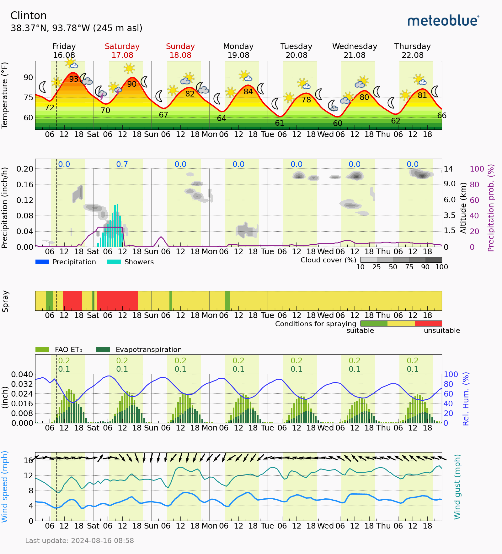
I will leave you with the weekly outlook courtesy of Brad Rippey, Ag Meteorologist USDA and our weekly area Meteogram.
In the West, warm, mostly dry weather favors fieldwork and crop development. A few showers are occurring, however, in
the northern Rockies and environs. Local reductions in air quality due to dozens of active wildfires are primarily focused
across the Northwest.
On the Plains, relentless heat prevails across Oklahoma and Texas. In Abilene, Texas, high temperatures have reached
100°F or higher each day this month, except August 9. Rangeland and pastures in Texas were rated 42% very poor to poor
on August 11, up six percentage points from the previous week. The southern Plains’ heat is also adversely affecting
immature summer crops, including some cotton and sorghum.
In the Corn Belt, showers and thunderstorms are associated with a low-pressure system over the upper Great Lakes region
and its attendant cold front. Early today, some of the heaviest showers are occurring in the eastern Corn Belt. With topsoil moisture having become limited in parts of the eastern Corn Belt—rated 40% very short to short on August 11 in
Ohio, along with 32% in Indiana—the rain is benefiting summer crops in the filling stage of development.
In the South, hot, humid conditions are especially prevalent from the western Gulf Coast region to the Mississippi Delta.
Despite the heat, producers are forging ahead with early-season harvest activities for a variety of crops, including corn and
rice. Meanwhile, a few thundershowers are entering the northern tier of the region, including parts of Tennessee and
Kentucky.
Outlook: Active weather associated with a cold front will continue to migrate eastward, reaching the Atlantic Coast States
later today into the weekend. Rainfall may become briefly heavy in the Northeast, with weekend totals reaching 1 to 3 inches
or more. Meanwhile, northbound Hurricane Ernesto will remain more than 500 miles east of the U.S. East Coast. Farther west,
a ridge of high pressure centered over southern sections of the Rockies and Plains will perpetuate a late-summer heat wave
and result in high temperatures frequently topping 105°F in parts of Texas. Hot, humid conditions will persist along and near
the Gulf Coast. Farther north, however, generally cooler-than-normal weather will cover the Midwest. West of the Mississippi
River, meaningful precipitation will be scarce during the next 5 days, although weekend showers associated with the Southwestern monsoon circulation may become briefly heavy in Arizona and Utah. The NWS 6- to 10-day outlook for August 21 –
25 calls for the likelihood of above-normal temperatures across the Plains, Rockies, Southwest, and Deep South, while coolerthan-normal conditions will cover parts of the Far West and an area stretching from the middle Mississippi Valley to the middle
and northern Atlantic States. Meanwhile, near- or below-normal rainfall across much of the country should contrast with
wetter-than-normal weather along the southern Atlantic Coast and from the Pacific Northwest to the northern High Plains.