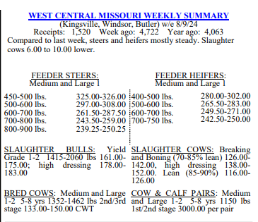


Hopefully most of those in West Central Missouri received some moisture over this last week. The area of rains this week were ever so scattered with no wide spread areas picking up that moisture. We had the strong cold front move through our area on Friday and we are left with beautiful temperatures here in WCMO. Our next real chance of rainfall comes in next weekend with a disturbance coming across the Midwest. The hay report I have been gathering from area farmers is incredible. It has been several years since I have seen as many bales being produced. The long term forecast is showing potential to be hay producing into the first week of October with at/above average temperatures as well as above average rainfall. One thing of note is that the LRC (Lezak Reoccurring Cycle) is showing the potential for our first freeze around the 10th-12th of October. Please keep in mind that the new cycle of the LRC model begins the 6th of October, so data from October 1st through Dec 1st is a bit hazy with the LRC until the pattern and days between become known. Please reach out if anyone needs a weather outlook via the LRC for September and I can email over your specific report for your specific area. I will leave you with the update from Brad Rippey and the USDA Ag Meteorology Dept. I have also attached the WCMO Weekly Cattle Report. Have a great week. Subby
In the West, dry weather and near- or above-normal temperatures favor summer crop maturation and harvesting. Triple digit (100-degree) heat has developed as far north as California’s Sacramento Valley, while today’s high temperatures will exceed 110°F in parts of the Desert Southwest. In Arizona, 71% of the cotton bolls were opening by August 25,
ahead of the 5-year average of 58%. On the Plains, cooler, wetter conditions are developing across parts of Oklahoma and northern Texas, following a protracted spell of hot, dry weather that significantly stressed rangeland, pastures, and immature summer crops. More than one-half (58%) of the rangeland and pastures in Texas were rated in very poor to poor condition on August 25, up from 36% just 3 weeks earlier. Meanwhile on the northern Plains, warm, dry weather is promoting small grain harvesting. In the Corn Belt, showers in the vicinity of a cold front stretch from Michigan to Missouri. The rain is providing beneficial moisture for filling summer crops, many of which have been subjected to drier-than-normal weather in recent weeks. A final day of hot weather prevails in the Ohio Valley, where today’s high temperatures will broadly top 95°F. In the South, local downpours persist near the Gulf Coast, especially in southern Louisiana. Hot, humid weather covers much of the remainder of the region, with thundershowers expected to become more numerous as the day progresses. Fieldwork, including corn and rice harvesting, continues where conditions permit. Outlook: Over the next few days, a cold front crossing the Midwest and Northeast will generate heavy showers and locally severe thunderstorms. The tail of the front will stall across the south-central U.S., leading to enhanced rainfall totals, especially across the southern Plains and the western Gulf Coast region. Five-day rainfall totals could reach 2 to 4 inches or more in parts of Texas, with much higher amounts possible in coastal sections of Texas and Louisiana. Across the remainder of the South, as well as the East and lower Midwest, rainfall could total 1 to 3 inches. In the wake of the cold front’s passage, cool, dry air will overspread the lower Midwest by Saturday and the Northeast by Sunday. Meanwhile, mostly dry weather will prevail during the next 5 days from the Pacific Coast to the northern and central Plains and the upper Midwest. Late-season heat will accompany the Western dry spell. The NWS 6- to 10-day outlook for September 4 – 8 calls for the likelihood of hotter-than-normal conditions along the Gulf Coast and northwest of a line from south-central New Mexico to Lake Superior. Near- or below-normal temperatures will cover the remainder of the country, including the mid-South, mid-Atlantic, much of the Midwest, and the southeastern half of the Plains. Meanwhile, near- or below-normal rainfall across the northern and western U.S. should contrast with wetter-than-normal weather from the southern Plains to the southern Atlantic Coast.