


Phil is being wanted after several days of 70° weather across the Midwest. Are we done with winter? No more snow? So many questions being asked as this seems to be such a warm and quiet winter. The fact is, we have had the storm systems come right now track. This is what the LRC does; it is the biggest piece of the atmospheric puzzle and uses the river of air above us at 18k feet along with cycling days to determine. However, smaller pieces of the puzzle such as the ENSO (La Nina’ and El Nino), Arctic Oscillation, North American Oscillation, etc make up the finishing touches of the long range forecast. Just a week, we picked up 1.5″ to 2.5″ of rainfall, with temperatures in the 40s/50s. IF this was all snow event, we could have been looking at 8″- 12″ of snow! We have had several other similar systems that ended up all liquid rain and no winter precipitation. The system last week I believed would be our best chance to see a significant ice storm when we did our Winter Forecast back the first week of December. We ended up just a bit too warm. The record setting warmth we have had this winter has been set really by 2 factors; first the set of the anchor ridges and anchor troughs (picture below):
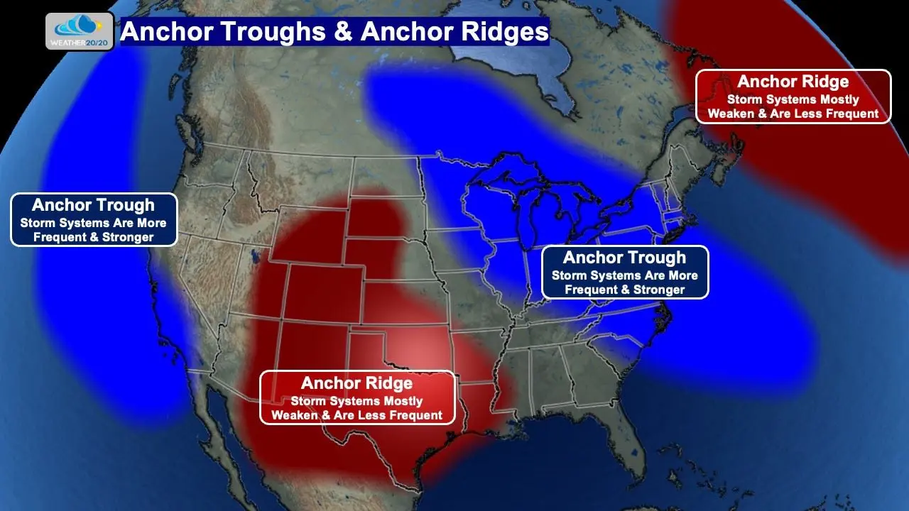
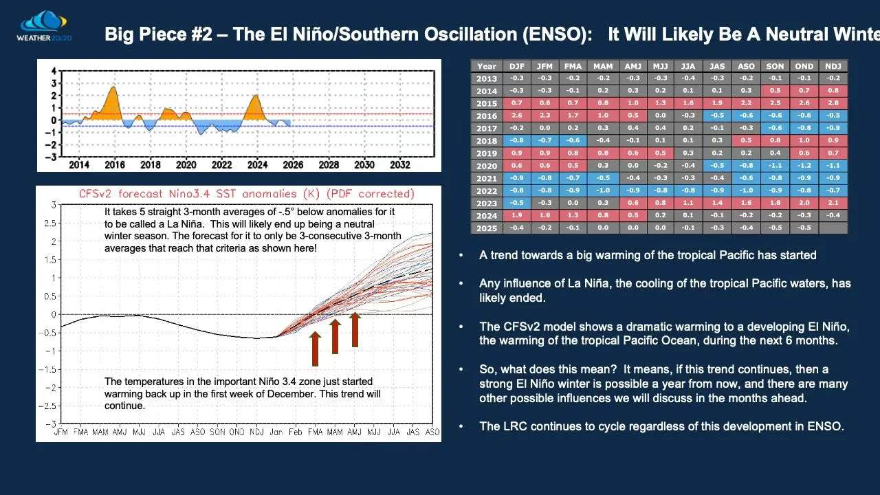
These have been forecasted back in November, when the LRC projected California to be very wet and Colorado very dry, contrast to what every other winter forecast was projecting. California has had record moisture and the slopes of the Colorado ski resorts are experiencing historically record lack of snow. We are in the middle of these ridges and troughs here in West Central Missouri. As the huge storm systems come in from California, they are weakened considerably across the anchor ridge to our west. With High Pressure Ridge, remember the air rotates clockwise around it. So as the weakened system hits the ridge, it goes up and over most of Missouri, then strengthens and nails the North East. This is exactly what is happening today, as a historical snow storm is blanketing the upper North East. In a High Pressure Ridge, air sinks and warms close to the surface, hence the well above average temperatures over the Great Plains. So we are in kinda like a battle ground for the air masses and the warm air has won majority of the time. This same cycle will likely continue through the summer and fall. This spells bad news for farmers and ranchers unless something changes. We are seeing a strong warming of the Pacific waters, transitioning into an ENSO neutral phase, and quite possible into a full El Nino by summer. I have had a discussion in previous blogs about what it takes to be El Nino and the repercussions. So basically, we could see a bit more moisture if this was to unfold. Here is a snapshot of what it takes for La Nina and El Nino below:
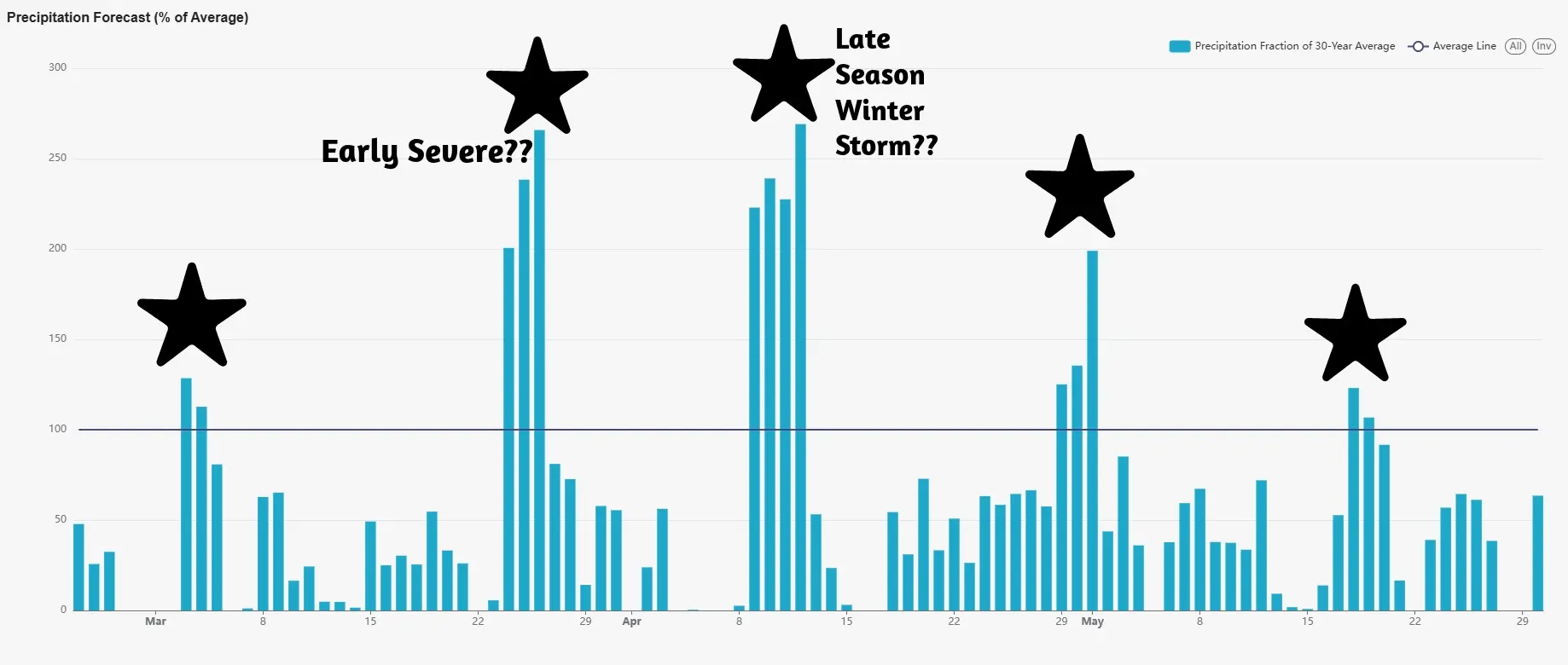
What does all this mean for the rest of Winter??? More well above average temperatures and continued cycle right on track. With this type of cycling mode, I think we do have a shot of seeing an early start to severe weather season, as well as a chance to see a late season snow in April. Here is a look at LRC Dashboard, and you can see storm systems and due dates by the stars. The soonest is Feb 23-26, in which we have a weak system moving into WCMO on Wednesday night. I think Ole’ Man Winter may still have a few tricks up its sleeve but Severe Suzie may enter into our lives by the 3rd/4th week of March.
This was a long look at our winter and if anyone has any questions, feel free to hit me up with any questions! I am looking forward to our Severe Weather Seminar staged for March 9th, at the Benson Center in Clinton, Mo at 6pm. We will have several storm chasers showing off their cars and tech and in an exciting video presentation, Gary Lezak will share his thoughts on WCMO spring and summer outlooks and what we need to prepare for. Hope to see you then!

