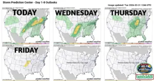

Good morning everyone! Yes, what a start to an active weather pattern with a lightning strike at Wilder RV Weather Center at 6:30am that knocked us out of power and off air for a period of time! We will see some sunshine coming out this afternoon with temperatures into the 80s before a front will move across our area, sparking some isolated showers and thunderstorms this evening and into the overnight hours. Our biggest threat from any of these stronger storms will be hail to the size of quarters. Wednesday afternoon we also have a chance to see more severe weather, with this time all modes of severe weather will be possible. Thursday we will likely just see showers and thundershowers, with severe risk being very low. Then we wrap things up on Friday, which in my opinion is our biggest day for potential severe weather, with showers and thunderstorms in the afternoon that will again have all modes of severe weather possible. Latest total rainfall accumulations through Saturday are showing 1.5″ to 2.25″ throughout West Central Missouri with some locations picking up closer to 3″ or more. We definitely need the rain, just not all the severe risks. I will leave you with the Storm Prediction Center’s risk assessment over the next few days. Have a great afternoon everyone! Subby