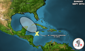
Good morning! It is just catastrophic what is ongoing in the east in portions of the Carolina’s and Tennessee due to the Hurricane Helene. Helene will be historic in terms of deaths, damage and displacement. Here in WCMO we are in a dry pattern as the Jet Stream continues to strengthen in Canada before its slow approach to signify a move into the Winter. Without any outside influences, WCMO looks to be dry for the next 10-14 days based on model data. BUT, there is yet another Tropical cluster of storms that is in the Caribbean and has a 50% chance of developing into a Tropical system and enter the Gulf of Mexico within the next 7 days. Current tracking shows moving north into the Gulf and affect Texas and the Louisiana coast. If this this happens, we could see some moisture from this system here in WCMO. The only problem is that many times with Tropical systems this time of year is that it gets caught up by a strong Low that frequent the High Plains as the Jet Streams begins its descent south across the country. This would push the system further east (Florida) and the moisture associated with it. We definitely need a bit more moisture here in our area for the fields. I will be taking a look at crop conditions for our bit on Subby’s Ag & Weather Report for Saturday. Subby